
Throughout the course of the year 2009, Agroinnovations worked with RMCI Inc. in the design and installation of irrigated alfalfa pastures. These laser-leveled irrigated pastures were installed as part of a Waste Water Treatment Facility project for the Acoma Pueblo. What follows are some of the design and engineering considerations in the implementation of these pastures. If you are interested in learning more about how to implement this type of system, then read on.
Step 1: Determine the Land Requirements
The first step was to determine the amount of land required to effectively move water out of the holding ponds and into the crop fields. We quickly realized that more land was required than initially thought. High volumes of water coming out of the facility would have been too much for the relatively small area initially under consideration. Additional land was desirable for the following reasons:
- Alfalfa is a crop that is highly susceptible to over-watering, as water logged roots make an easy target for soil-borne bacteria and other diseases that can easily weaken or kill a stand of alfalfa when conditions are favorable.
- The highly precise laser leveling of the field will greatly increase the field’s irrigation efficiency, as the water will move across the surface and penetrate deeply into the soil profile.
- Taking into account the rainfall events, which although they are infrequent in the desert Southwest, can sometimes be torrential and well above averages in our highly variable climate.
The table below represents my analysis of the amount of land required to effectively meet the needs of the treatment facility. As can be seen in the summary table, the House Count Estimate, which is the anticipated flow for the facility, will require 16 acres of land at an application rate of 2.75 acre/feet year.
Table 1: Water and Land Requirements.

Luckily, the tribe was able to add additional land to the project, which greatly helped to meet the facility’s discharge requirements
Step 2: Build a 3-D surface
Next, a statistical interpolation method was used to create a 3-D surface of the designated work area. This was done using GRASS GIS, and was used to generate the site contour lines and to perform a water-flow analysis of the work area using the survey points. The interpolated surface allowed precise elevation points to be placed on a 100′ x 100′ grid.
Step 3: Cut-Fill Analysis
With grid in hand, I then processed the data using Plane Surface Design software, which automates the cut-fill analysis for the site. A cut-fill map is used by the leveling equipment operator as a guide while he removes dirt from high points (cuts) while bringing it to lower areas (fills). This map gives the operator precise instructions on the depth of cuts and fills across the 100′ x 100′ virtual surface.
Cut-fill maps were designed using at a 1/10th foot drop per 100 feet with a cut-fill ratio of 1.3. A sample cut-fill map is provided below. Though this map was not the one we used in the final design, it gives a good sense of the look and feel of a cut-fill map.

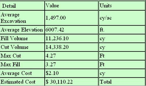
Below I have summarized the results of a typical cut fill analysis in terms of average excavation, fill volume, cut volume, and max cut/max fill.
Table 2: Summary of cut-fill analysis
Step 4: Evaluate Options
I developed for the team’s considerations a set of four different options for irrigating the alfalfa fields. These options helped us to weight the cost-benefit for different piping and watering configurations.
Each option has three associated maps :
- a waterflow-bench map
- a cut-fill map, and
- a dimensioned materials drawing
Each option has its own advantages and disadvantages like options that use less pipe and fewer valves but require more earthwork. The below table outlines the Materials Requirements for each Irrigation Option.

Irrigation System Design
After choosing the preferred of the four options, the next step in this process was the Design of the Irrigation system.
The pipelines and 12 alfalfa sunshine valves, with 8 along the Northern edge and 4 at the Southern edge of the wastewater treatment facility were placed at a distance of 45’ between each valve to enable the operator greater versatility in the irrigation management and also to ensure that no dead spots will exist where water is unable to penetrate.